


05-JUIL-16 16:00:46

BernardHumeau
User
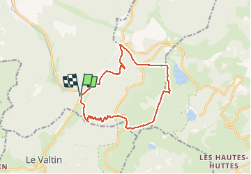

Length
14.1 km

Max alt
1304 m

Uphill gradient
681 m
Km-Effort
23 km

Min alt
699 m

Downhill gradient
679 m
Boucle
Yes
Creation date :
2019-07-29 13:21:40.088
Updated on :
2020-12-30 17:49:53.704
4h45
Difficulty : Very difficult

FREE GPS app for hiking
 SityTrail
IGN / Geographical institutes
SityTrail Plus
The world is yours!
About
Trail Walking of 14.1 km to be discovered at Grand Est, Vosges, Plainfaing. This trail is proposed by BernardHumeau.
Description
Départ : étang des Dames (LE RUDLIN)
Rando difficile : fort dénivelé pour atteindre la crête, mais vue imprenable.
Positioning
Country:
France
Region :
Grand Est
Department/Province :
Vosges
Municipality :
Plainfaing
Location:
Unknown
Start:(Dec)
Start:(UTM)
354271 ; 5331412 (32U) N.
Comments