


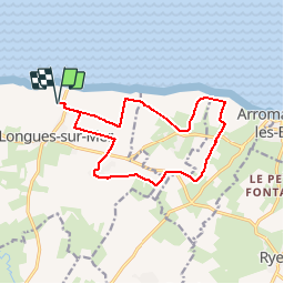
De la batterie de Longues au cap Manvieux

aubinjoel
User


FREE GPS app for hiking
 SityTrail
IGN / Geographical institutes
SityTrail Plus
The world is yours!
About
Trail of 12.8 km to be discovered at Normandy, Calvados, Longues-sur-Mer. This trail is proposed by aubinjoel.
Description
Depuis le site de la Batterie allemande de Longues-sur-Mer, ouvrage majeur du Mur de l'Atlantique, partez cheminer sur les hauteurs des falaises du Bessin. Ce circuit vous offrira un panorama imprenable sur les vestiges du port artificiel d'Arromanches.


Positioning
Comments