


Tête de L ESTROP

trailer.nono
User
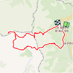

Length
21 km

Max alt
2938 m

Uphill gradient
1742 m
Km-Effort
44 km

Min alt
1744 m

Downhill gradient
1729 m
Boucle
No
Creation date :
2019-07-31 07:33:14.607
Updated on :
2019-08-01 14:20:37.88
6h05
Difficulty : Difficult

FREE GPS app for hiking
 SityTrail
IGN / Geographical institutes
SityTrail Plus
The world is yours!
About
Trail Walking of 21 km to be discovered at Provence-Alpes-Côte d'Azur, Alpes-de-Haute-Provence, Allos. This trail is proposed by trailer.nono.
Positioning
Country:
France
Region :
Provence-Alpes-Côte d'Azur
Department/Province :
Alpes-de-Haute-Provence
Municipality :
Allos
Location:
Unknown
Start:(Dec)
Start:(UTM)
306131 ; 4906781 (32T) N.
Comments