


les 2 lacs et montchal

jeanic63
User
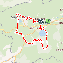

Length
19.4 km

Max alt
1461 m

Uphill gradient
617 m
Km-Effort
28 km

Min alt
1159 m

Downhill gradient
615 m
Boucle
Yes
Creation date :
2019-08-01 07:38:22.528
Updated on :
2019-08-02 05:38:39.482
6h03
Difficulty : Difficult

FREE GPS app for hiking
 SityTrail
IGN / Geographical institutes
SityTrail Plus
The world is yours!
About
Trail Walking of 19.4 km to be discovered at Auvergne-Rhône-Alpes, Puy-de-Dôme, Besse-et-Saint-Anastaise. This trail is proposed by jeanic63.
Description
départ parking lac Pavin
Positioning
Country:
France
Region :
Auvergne-Rhône-Alpes
Department/Province :
Puy-de-Dôme
Municipality :
Besse-et-Saint-Anastaise
Location:
Besse
Start:(Dec)
Start:(UTM)
491436 ; 5038717 (31T) N.
Comments