


saint sauveur de camprieu

labarone
User
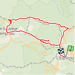

Length
22 km

Max alt
1463 m

Uphill gradient
620 m
Km-Effort
30 km

Min alt
1097 m

Downhill gradient
613 m
Boucle
No
Creation date :
2019-07-31 06:36:13.266
Updated on :
2019-08-03 04:33:03.424
6h37
Difficulty : Medium

FREE GPS app for hiking
 SityTrail
IGN / Geographical institutes
SityTrail Plus
The world is yours!
About
Trail Walking of 22 km to be discovered at Occitania, Gard, Val-d'Aigoual. This trail is proposed by labarone.
Description
Bien
Positioning
Country:
France
Region :
Occitania
Department/Province :
Gard
Municipality :
Val-d'Aigoual
Location:
Valleraugue
Start:(Dec)
Start:(UTM)
543928 ; 4882541 (31T) N.
Comments