


Jour 5 - Refuge des Lacs Merlet -> Retour case départ

gregou74
User
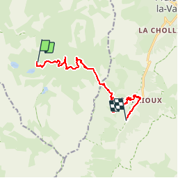

Length
11.2 km

Max alt
2528 m

Uphill gradient
379 m
Km-Effort
18.5 km

Min alt
1714 m

Downhill gradient
1060 m
Boucle
No
Creation date :
2019-08-03 07:45:19.804
Updated on :
2019-08-03 07:46:30.391
3h23
Difficulty : Difficult

FREE GPS app for hiking
 SityTrail
IGN / Geographical institutes
SityTrail Plus
The world is yours!
About
Trail Walking of 11.2 km to be discovered at Auvergne-Rhône-Alpes, Savoy, Courchevel. This trail is proposed by gregou74.
Positioning
Country:
France
Region :
Auvergne-Rhône-Alpes
Department/Province :
Savoy
Municipality :
Courchevel
Location:
Saint-Bon-Tarentaise
Start:(Dec)
Start:(UTM)
316099 ; 5025744 (32T) N.
Comments