


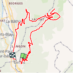
Boucle Cevins- Benetant- La Bathie

franquen
User

Length
30 km

Max alt
1560 m

Uphill gradient
1346 m
Km-Effort
48 km

Min alt
370 m

Downhill gradient
1370 m
Boucle
No
Creation date :
2019-08-03 08:05:51.742
Updated on :
2019-08-03 16:12:23.847
4h26
Difficulty : Medium

FREE GPS app for hiking
 SityTrail
IGN / Geographical institutes
SityTrail Plus
The world is yours!
About
Trail Electric bike of 30 km to be discovered at Auvergne-Rhône-Alpes, Savoy, Cevins. This trail is proposed by franquen.
Description
Rando sympa dans la forêt sur des routes et chemins déserts.
à Menetant avons pris le chemin menant aux lacs des tempêtes et aux anciennes ardoiseries mais pas assez de batterie pour aller les visiter!
Positioning
Country:
France
Region :
Auvergne-Rhône-Alpes
Department/Province :
Savoy
Municipality :
Cevins
Location:
Unknown
Start:(Dec)
Start:(UTM)
301571 ; 5051685 (32T) N.
Comments