


Tarn

JLDECK
User
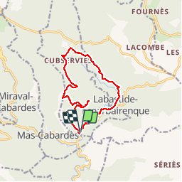

Length
14.4 km

Max alt
799 m

Uphill gradient
581 m
Km-Effort
22 km

Min alt
316 m

Downhill gradient
580 m
Boucle
Yes
Creation date :
2019-08-03 10:15:56.808
Updated on :
2019-08-03 16:28:11.468
5h42
Difficulty : Medium

FREE GPS app for hiking
 SityTrail
IGN / Geographical institutes
SityTrail Plus
The world is yours!
About
Trail Walking of 14.4 km to be discovered at Occitania, Aude, Roquefère. This trail is proposed by JLDECK.
Positioning
Country:
France
Region :
Occitania
Department/Province :
Aude
Municipality :
Roquefère
Location:
Unknown
Start:(Dec)
Start:(UTM)
449545 ; 4802232 (31T) N.
Comments