


île d'Oléron 1

MMarie
User
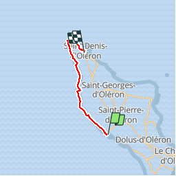

Length
24 km

Max alt
14 m

Uphill gradient
103 m
Km-Effort
25 km

Min alt
-1 m

Downhill gradient
104 m
Boucle
No
Creation date :
2014-12-10 00:00:00.0
Updated on :
2014-12-10 00:00:00.0
6h59
Difficulty : Medium

FREE GPS app for hiking
 SityTrail
IGN / Geographical institutes
SityTrail Plus
The world is yours!
About
Trail Walking of 24 km to be discovered at New Aquitaine, Charente-Maritime, Saint-Pierre-d'Oléron. This trail is proposed by MMarie.
Photos

Positioning
Country:
France
Region :
New Aquitaine
Department/Province :
Charente-Maritime
Municipality :
Saint-Pierre-d'Oléron
Location:
Unknown
Start:(Dec)
Start:(UTM)
629350 ; 5086203 (30T) N.
Comments