


plomb du cantal

Robertplessier
User
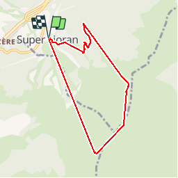

Length
7.4 km

Max alt
1797 m

Uphill gradient
608 m
Km-Effort
15.5 km

Min alt
1235 m

Downhill gradient
610 m
Boucle
Yes
Creation date :
2019-08-04 08:17:19.66
Updated on :
2019-08-04 14:34:23.596
6h16
Difficulty : Very easy

FREE GPS app for hiking
 SityTrail
IGN / Geographical institutes
SityTrail Plus
The world is yours!
About
Trail Walking of 7.4 km to be discovered at Auvergne-Rhône-Alpes, Cantal, Laveissière. This trail is proposed by Robertplessier.
Positioning
Country:
France
Region :
Auvergne-Rhône-Alpes
Department/Province :
Cantal
Municipality :
Laveissière
Location:
Unknown
Start:(Dec)
Start:(UTM)
480307 ; 4992229 (31T) N.
Comments