


2019 08 poigny T1

michel1025
User
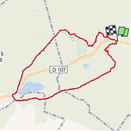

Length
8.5 km

Max alt
175 m

Uphill gradient
115 m
Km-Effort
10 km

Min alt
134 m

Downhill gradient
122 m
Boucle
Yes
Creation date :
2019-08-04 13:32:48.0
Updated on :
2019-08-04 15:42:50.5
2h08
Difficulty : Unknown

FREE GPS app for hiking
 SityTrail
IGN / Geographical institutes
SityTrail Plus
The world is yours!
About
Trail Walking of 8.5 km to be discovered at Ile-de-France, Yvelines, Poigny-la-Forêt. This trail is proposed by michel1025.
Positioning
Country:
France
Region :
Ile-de-France
Department/Province :
Yvelines
Municipality :
Poigny-la-Forêt
Location:
Unknown
Start:(Dec)
Start:(UTM)
407080 ; 5391809 (31U) N.
Comments