


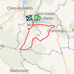
Maysel 9.4

Djaie60
User

Length
9.4 km

Max alt
145 m

Uphill gradient
172 m
Km-Effort
11.7 km

Min alt
31 m

Downhill gradient
172 m
Boucle
Yes
Creation date :
2019-08-05 08:40:57.636
Updated on :
2019-08-05 09:02:24.535
2h38
Difficulty : Medium

FREE GPS app for hiking
 SityTrail
IGN / Geographical institutes
SityTrail Plus
The world is yours!
About
Trail Walking of 9.4 km to be discovered at Hauts-de-France, Oise, Maysel. This trail is proposed by Djaie60.
Positioning
Country:
France
Region :
Hauts-de-France
Department/Province :
Oise
Municipality :
Maysel
Location:
Unknown
Start:(Dec)
Start:(UTM)
454500 ; 5456594 (31U) N.
Comments