


mezilhac champ de mars

raab
User
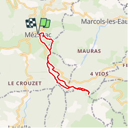

Length
11.8 km

Max alt
1337 m

Uphill gradient
326 m
Km-Effort
16.1 km

Min alt
1139 m

Downhill gradient
327 m
Boucle
Yes
Creation date :
2019-08-05 07:34:33.286
Updated on :
2019-08-05 13:54:58.497
3h38
Difficulty : Medium

FREE GPS app for hiking
 SityTrail
IGN / Geographical institutes
SityTrail Plus
The world is yours!
About
Trail Walking of 11.8 km to be discovered at Auvergne-Rhône-Alpes, Ardèche, Mézilhac. This trail is proposed by raab.
Positioning
Country:
France
Region :
Auvergne-Rhône-Alpes
Department/Province :
Ardèche
Municipality :
Mézilhac
Location:
Unknown
Start:(Dec)
Start:(UTM)
606887 ; 4962523 (31T) N.
Comments