


Saint prémilitaire

poule16
User
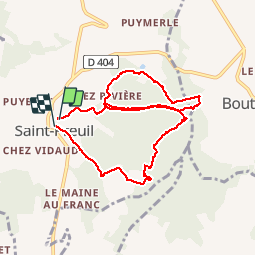

Length
9.2 km

Max alt
143 m

Uphill gradient
144 m
Km-Effort
11.1 km

Min alt
83 m

Downhill gradient
135 m
Boucle
Yes
Creation date :
2019-08-08 09:23:12.0
Updated on :
2019-08-08 12:06:04.754
2h36
Difficulty : Unknown

FREE GPS app for hiking
 SityTrail
IGN / Geographical institutes
SityTrail Plus
The world is yours!
About
Trail Walking of 9.2 km to be discovered at New Aquitaine, Charente, Saint-Preuil. This trail is proposed by poule16.
Positioning
Country:
France
Region :
New Aquitaine
Department/Province :
Charente
Municipality :
Saint-Preuil
Location:
Unknown
Start:(Dec)
Start:(UTM)
720647 ; 5053239 (30T) N.
Comments