


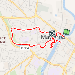
Mayenne

COGLAIS3
User

Length
4 km

Max alt
142 m

Uphill gradient
66 m
Km-Effort
4.9 km

Min alt
89 m

Downhill gradient
64 m
Boucle
Yes
Creation date :
2019-08-08 12:44:10.328
Updated on :
2019-08-08 14:07:47.904
1h23
Difficulty : Very easy

FREE GPS app for hiking
 SityTrail
IGN / Geographical institutes
SityTrail Plus
The world is yours!
About
Trail Walking of 4 km to be discovered at Pays de la Loire, Mayenne, Mayenne. This trail is proposed by COGLAIS3.
Description
Boucle en ville
Positioning
Country:
France
Region :
Pays de la Loire
Department/Province :
Mayenne
Municipality :
Mayenne
Location:
Unknown
Start:(Dec)
Start:(UTM)
676842 ; 5352845 (30U) N.
Comments