


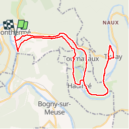
Monthermé Thilay avec ou sans voie verte

choumac08
User

Length
21 km

Max alt
214 m

Uphill gradient
318 m
Km-Effort
25 km

Min alt
134 m

Downhill gradient
318 m
Boucle
Yes
Creation date :
2019-07-25 13:43:07.935
Updated on :
2019-08-10 07:44:11.923
1h19
Difficulty : Very easy

FREE GPS app for hiking
 SityTrail
IGN / Geographical institutes
SityTrail Plus
The world is yours!
About
Trail Mountain bike of 21 km to be discovered at Grand Est, Ardennes, Monthermé. This trail is proposed by choumac08.
Positioning
Country:
France
Region :
Grand Est
Department/Province :
Ardennes
Municipality :
Monthermé
Location:
Unknown
Start:(Dec)
Start:(UTM)
625121 ; 5527000 (31U) N.
Comments