


SityTrail -

jeanic63
User
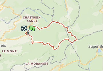

Length
14.3 km

Max alt
1862 m

Uphill gradient
687 m
Km-Effort
23 km

Min alt
1278 m

Downhill gradient
684 m
Boucle
Yes
Creation date :
2019-08-10 13:18:14.996
Updated on :
2022-07-11 19:11:30.281
--
Difficulty : Difficult

FREE GPS app for hiking
 SityTrail
IGN / Geographical institutes
SityTrail Plus
The world is yours!
About
Trail On foot of 14.3 km to be discovered at Auvergne-Rhône-Alpes, Puy-de-Dôme, Chastreix. This trail is proposed by jeanic63.
Description
depart à 1 KM environ apres le village (les bughes)direction la station chastreix le sancy
Positioning
Country:
France
Region :
Auvergne-Rhône-Alpes
Department/Province :
Puy-de-Dôme
Municipality :
Chastreix
Location:
Unknown
Start:(Dec)
Start:(UTM)
482123 ; 5040885 (31T) N.
Comments