


Circuit no 10

phil21
User
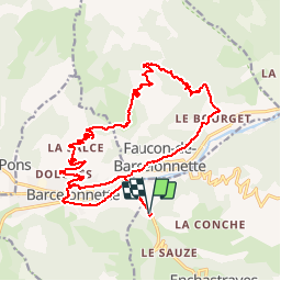

Length
24 km

Max alt
1790 m

Uphill gradient
780 m
Km-Effort
34 km

Min alt
1133 m

Downhill gradient
781 m
Boucle
Yes
Creation date :
2019-08-11 07:28:00.0
Updated on :
2019-08-11 09:25:51.356
1h57
Difficulty : Very difficult

FREE GPS app for hiking
 SityTrail
IGN / Geographical institutes
SityTrail Plus
The world is yours!
About
Trail Mountain bike of 24 km to be discovered at Provence-Alpes-Côte d'Azur, Alpes-de-Haute-Provence, Enchastrayes. This trail is proposed by phil21.
Positioning
Country:
France
Region :
Provence-Alpes-Côte d'Azur
Department/Province :
Alpes-de-Haute-Provence
Municipality :
Enchastrayes
Location:
Unknown
Start:(Dec)
Start:(UTM)
314815 ; 4916934 (32T) N.
Comments