


Kévin randonnée

GUERLACH
User

Length
10.6 km

Max alt
519 m

Uphill gradient
353 m
Km-Effort
15.4 km

Min alt
337 m

Downhill gradient
371 m
Boucle
Yes
Creation date :
2019-08-11 06:36:46.246
Updated on :
2019-08-11 15:12:34.249
3h24
Difficulty : Difficult

FREE GPS app for hiking
 SityTrail
IGN / Geographical institutes
SityTrail Plus
The world is yours!
About
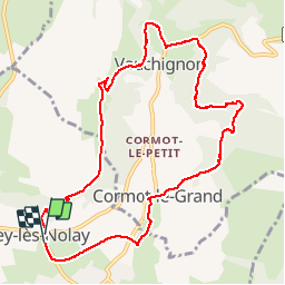
Trail Walking of 10.6 km to be discovered at Bourgogne-Franche-Comté, Côte-d'Or, Nolay. This trail is proposed by GUERLACH.
Description
Au retour vers Cirey-les-Nolay, la grimpette pour accéder au viaduc est très glissante. Faire très attention, sur tout s'il a plut.
Positioning
Country:
France
Region :
Bourgogne-Franche-Comté
Department/Province :
Côte-d'Or
Municipality :
Nolay
Location:
Unknown
Start:(Dec)
Start:(UTM)
623735 ; 5201820 (31T) N.
Comments