


Lyons la Forêt 2

RC76
User
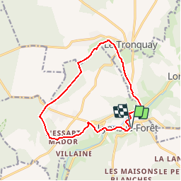

Length
12.4 km

Max alt
181 m

Uphill gradient
207 m
Km-Effort
15.1 km

Min alt
80 m

Downhill gradient
212 m
Boucle
Yes
Creation date :
2014-12-10 00:00:00.0
Updated on :
2014-12-10 00:00:00.0
3h17
Difficulty : Easy

FREE GPS app for hiking
 SityTrail
IGN / Geographical institutes
SityTrail Plus
The world is yours!
About
Trail Walking of 12.4 km to be discovered at Normandy, Eure, Lyons-la-Forêt. This trail is proposed by RC76.
Description
Les tainières, le Tronquet
Positioning
Country:
France
Region :
Normandy
Department/Province :
Eure
Municipality :
Lyons-la-Forêt
Location:
Unknown
Start:(Dec)
Start:(UTM)
389634 ; 5472906 (31U) N.
Comments