


Rando Tête de Vinaigre - Pte de Colombart

trailer.nono
User

Length
24 km

Max alt
2606 m

Uphill gradient
1381 m
Km-Effort
42 km

Min alt
1491 m

Downhill gradient
1386 m
Boucle
Yes
Creation date :
2019-08-12 07:57:53.318
Updated on :
2019-08-12 15:10:13.271
5h15
Difficulty : Easy

FREE GPS app for hiking
 SityTrail
IGN / Geographical institutes
SityTrail Plus
The world is yours!
About
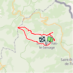
Trail Walking of 24 km to be discovered at Provence-Alpes-Côte d'Azur, Maritime Alps, Saint-Dalmas-le-Selvage. This trail is proposed by trailer.nono.
Positioning
Country:
France
Region :
Provence-Alpes-Côte d'Azur
Department/Province :
Maritime Alps
Municipality :
Saint-Dalmas-le-Selvage
Location:
Unknown
Start:(Dec)
Start:(UTM)
329638 ; 4905627 (32T) N.
Comments