


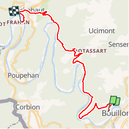
gr16 bouillon frahal

vanessadebreux
User

Length
14.7 km

Max alt
381 m

Uphill gradient
446 m
Km-Effort
21 km

Min alt
193 m

Downhill gradient
570 m
Boucle
No
Creation date :
2019-08-13 10:33:31.433
Updated on :
2019-08-13 14:22:54.242
3h32
Difficulty : Very difficult

FREE GPS app for hiking
 SityTrail
IGN / Geographical institutes
SityTrail Plus
The world is yours!
About
Trail Trail of 14.7 km to be discovered at Wallonia, Luxembourg, Bouillon. This trail is proposed by vanessadebreux.
Description
rando,gr16
Photos

Positioning
Country:
Belgium
Region :
Wallonia
Department/Province :
Luxembourg
Municipality :
Bouillon
Location:
Bouillon
Start:(Dec)
Start:(UTM)
648382 ; 5517916 (31U) N.
Comments
le parcours n'a pas été corrigé sur l'application pc. Le point de départ est tout à fait aléatoire dans le bois et il ne correspond pas au tracé GR 16. Regardez le parcours "GR 16 Bouillon Récréalle" que j'ai réalisé. Vous pourrez le raccourcir en vous arrêtant à la passerelle de Frahan.