


Pic de Bure 2709 m

Atchoum26
User

Length
27 km

Max alt
2696 m

Uphill gradient
2088 m
Km-Effort
55 km

Min alt
1344 m

Downhill gradient
2078 m
Boucle
Yes
Creation date :
2019-08-13 08:10:40.0
Updated on :
2019-08-13 16:03:33.782
7h50
Difficulty : Very difficult

FREE GPS app for hiking
 SityTrail
IGN / Geographical institutes
SityTrail Plus
The world is yours!
About
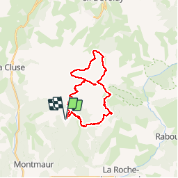
Trail Trail of 27 km to be discovered at Provence-Alpes-Côte d'Azur, Hautes-Alpes, Montmaur. This trail is proposed by Atchoum26.
Description
Col de Conode 1789 m - Pas du Follet 2129 m - Chalet du Vallon d’Ane 1700 m - Combe Ratin - Pic de Bure 2709 m - Combe d’Aurouze - Sauvas 1343 m
Positioning
Country:
France
Region :
Provence-Alpes-Côte d'Azur
Department/Province :
Hautes-Alpes
Municipality :
Montmaur
Location:
Unknown
Start:(Dec)
Start:(UTM)
730529 ; 4942860 (31T) N.
Comments