


2013-08-26 Vercors - Le Bruyant - Le Bec d'Aigle

jchezlemas
User
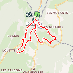

Length
9 km

Max alt
1138 m

Uphill gradient
367 m
Km-Effort
13.9 km

Min alt
906 m

Downhill gradient
372 m
Boucle
Yes
Creation date :
2014-12-10 00:00:00.0
Updated on :
2014-12-10 00:00:00.0
2h56
Difficulty : Medium

FREE GPS app for hiking
 SityTrail
IGN / Geographical institutes
SityTrail Plus
The world is yours!
About
Trail Walking of 9 km to be discovered at Auvergne-Rhône-Alpes, Isère, Lans-en-Vercors. This trail is proposed by jchezlemas.
Positioning
Country:
France
Region :
Auvergne-Rhône-Alpes
Department/Province :
Isère
Municipality :
Lans-en-Vercors
Location:
Unknown
Start:(Dec)
Start:(UTM)
704726 ; 5003332 (31T) N.
Comments