


Rabuons pas de l ischator pas du Ténibre

trailer.nono
User

Length
34 km

Max alt
2928 m

Uphill gradient
3285 m
Km-Effort
77 km

Min alt
1082 m

Downhill gradient
3282 m
Boucle
Yes
Creation date :
2019-08-13 05:35:12.582
Updated on :
2019-08-13 17:39:32.992
11h09
Difficulty : Difficult

FREE GPS app for hiking
 SityTrail
IGN / Geographical institutes
SityTrail Plus
The world is yours!
About
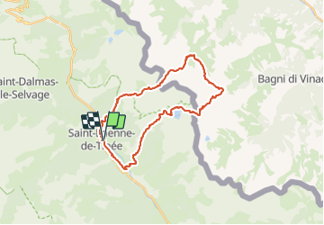
Trail Walking of 34 km to be discovered at Provence-Alpes-Côte d'Azur, Maritime Alps, Saint-Étienne-de-Tinée. This trail is proposed by trailer.nono.
Positioning
Country:
France
Region :
Provence-Alpes-Côte d'Azur
Department/Province :
Maritime Alps
Municipality :
Saint-Étienne-de-Tinée
Location:
Unknown
Start:(Dec)
Start:(UTM)
334546 ; 4902361 (32T) N.
Comments