Trail Mountain bike Montel-de-Gelat - Montel Auzances VTT - Photo
 1stef1
1stef1

User

© OpenStreetMap contributors
Length
Length
35 km
Max alt
Max alt
732 m
Uphill gradient
Uphill gradient
586 m
Km-Effort
Km-Effort  
42 km
Min alt
Min alt
492 m
Downhill gradient
Downhill gradient
597 m
Boucle
Boucle
No
Creation date :
2019-08-13 13:53:40.377
Updated on :
2019-08-13 20:39:12.973

(0 Reviews)

Mountain bike
Mountain bike
2h37
Difficulty : Very easy

Scan this QR Code to open this trail in the SityTrail application

FREE GPS app for hiking

Logo SityTrail SityTrail

IGN / Geographical institutes

Download SityTrail from the App Store Download SityTrail from Google Play

Logo SityTrail SityTrail World

The world is yours!

Download SityTrail from the App Store Download SityTrail from Google Play Download SityTrail on Huawei AppGallery

About

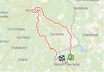
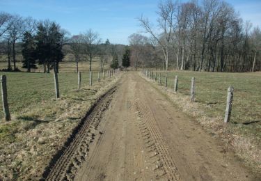
Trail Mountain bike of 35 km to be discovered at Auvergne-Rhône-Alpes, Puy-de-Dôme, Montel-de-Gelat. This trail is proposed by 1stef1.

Description

Très facile en pilotage , grand chemins ou mini départementales mais 35 km tout de même et 600 Mt de dénivelé...

Elevation profile

Photos

Positioning

Country:
France
Region :
Auvergne-Rhône-Alpes
Department/Province :
Puy-de-Dôme
Municipality :
Montel-de-Gelat
Location:
Unknown
Start:(UTM)
467588 ; 5087168 (31T) N.

Trails nearby

Trail On foot Villossanges - Croix de Milan - Photo
On foot
PRO

On foot

Easy
Villossanges, Auvergne-Rhône-Alpes, Puy-de-Dôme, France
8.1 km | 10.2 km-effort
2h 18min
Yes
Trail On foot Villossanges - Les Etangs - Photo
On foot
PRO

On foot

Medium
Villossanges, Auvergne-Rhône-Alpes, Puy-de-Dôme, France
17.6 km | 21 km-effort
4h 41min
Yes
Trail On foot Condat-en-Combraille - Ferme de Pacros - Photo
On foot
PRO

On foot

Easy
Condat-en-Combraille, Auvergne-Rhône-Alpes, Puy-de-Dôme, France
10.1 km | 12.4 km-effort
2h 48min
No
Trail Walking Montel-de-Gelat - Montel de Gelat - Photo
Walking
tracegps

Walking

Medium
Montel-de-Gelat, Auvergne-Rhône-Alpes, Puy-de-Dôme, France
18.2 km | 21 km-effort
5h 0min
Yes
Trail Walking Tralaigues - La ferme de Pacros - Tralaigues - Photo
Walking
tracegps

Walking

Medium
Tralaigues, Auvergne-Rhône-Alpes, Puy-de-Dôme, France
10.8 km | 13.2 km-effort
3h 0min
Yes
Trail Walking Dontreix - dontreix rocher de St. Julien - Photo
Walking
poutifar

Walking

Very easy
Dontreix, New Aquitaine, Creuse, France
7.4 km | 9.4 km-effort
Unknown
Yes
Trail Walking Dontreix - dontreix rocher de St. Julien - Photo
Walking
poutifar

Walking

Very easy
Dontreix, New Aquitaine, Creuse, France
7.4 km | 9.4 km-effort
Unknown
Yes
Trail Walking Charensat - forêt de Charensat - Photo
Walking
1stef1

Walking

Very easy
Charensat, Auvergne-Rhône-Alpes, Puy-de-Dôme, France
2.6 km | 3.2 km-effort
1h 0min
Yes
Trail Road bike Villossanges - breux pontau etienne conda - Photo
Road bike
1stef1

Road bike

Very difficult
(1)
Villossanges, Auvergne-Rhône-Alpes, Puy-de-Dôme, France
39 km | 48 km-effort
2h 45min
Yes


Close
My subscriptions