


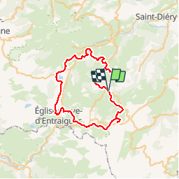
Circuit des lacs : Godivelle, Chauvet, Pavin, Montcineyre, Bourdouze

PsyPezman
User

Length
57 km

Max alt
1398 m

Uphill gradient
1438 m
Km-Effort
76 km

Min alt
950 m

Downhill gradient
1436 m
Boucle
Yes
Creation date :
2019-08-14 12:49:21.246
Updated on :
2019-08-18 07:51:43.866
16h57
Difficulty : Very difficult

FREE GPS app for hiking
 SityTrail
IGN / Geographical institutes
SityTrail Plus
The world is yours!
About
Trail Walking of 57 km to be discovered at Auvergne-Rhône-Alpes, Puy-de-Dôme, Compains. This trail is proposed by PsyPezman.

Positioning
Country:
France
Region :
Auvergne-Rhône-Alpes
Department/Province :
Puy-de-Dôme
Municipality :
Compains
Location:
Unknown
Start:(Dec)
Start:(UTM)
494312 ; 5032005 (31T) N.
Comments