


saine

Dupuybadonniere
User

Length
7.3 km

Max alt
845 m

Uphill gradient
177 m
Km-Effort
9.7 km

Min alt
696 m

Downhill gradient
177 m
Boucle
Yes
Creation date :
2019-08-05 12:35:02.178
Updated on :
2019-08-15 21:55:51.493
2h34
Difficulty : Very easy

FREE GPS app for hiking
 SityTrail
IGN / Geographical institutes
SityTrail Plus
The world is yours!
About
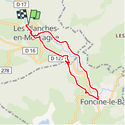
Trail Walking of 7.3 km to be discovered at Bourgogne-Franche-Comté, Jura, Les Planches-en-Montagne. This trail is proposed by Dupuybadonniere.
Positioning
Country:
France
Region :
Bourgogne-Franche-Comté
Department/Province :
Jura
Municipality :
Les Planches-en-Montagne
Location:
Unknown
Start:(Dec)
Start:(UTM)
270905 ; 5171276 (32T) N.
Comments