


Sainte croix, coulombs, Saint Gabriel

vienne14400
User

Length
24 km

Max alt
75 m

Uphill gradient
199 m
Km-Effort
27 km

Min alt
13 m

Downhill gradient
198 m
Boucle
Yes
Creation date :
2019-08-16 12:39:50.571
Updated on :
2019-08-16 14:21:34.334
1h41
Difficulty : Very easy

FREE GPS app for hiking
 SityTrail
IGN / Geographical institutes
SityTrail Plus
The world is yours!
About
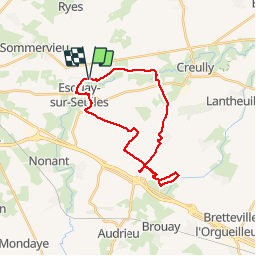
Trail Mountain bike of 24 km to be discovered at Normandy, Calvados, Vienne-en-Bessin. This trail is proposed by vienne14400.
Photos


Positioning
Country:
France
Region :
Normandy
Department/Province :
Calvados
Municipality :
Vienne-en-Bessin
Location:
Unknown
Start:(Dec)
Start:(UTM)
673644 ; 5461232 (30U) N.
Comments