


SNS GIVRY EN ARGONNE

Patrick Martinus
User
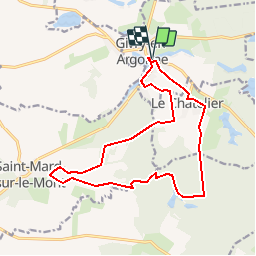

Length
15.5 km

Max alt
187 m

Uphill gradient
138 m
Km-Effort
17.3 km

Min alt
155 m

Downhill gradient
138 m
Boucle
Yes
Creation date :
2019-08-17 07:49:04.814
Updated on :
2019-08-17 07:50:20.895
3h49
Difficulty : Difficult

FREE GPS app for hiking
 SityTrail
IGN / Geographical institutes
SityTrail Plus
The world is yours!
About
Trail Walking of 15.5 km to be discovered at Grand Est, Marne, Givry-en-Argonne. This trail is proposed by Patrick Martinus.
Description
Terrain mi champêtre mi bois
Positioning
Country:
France
Region :
Grand Est
Department/Province :
Marne
Municipality :
Givry-en-Argonne
Location:
Unknown
Start:(Dec)
Start:(UTM)
638382 ; 5423292 (31U) N.
Comments