


Autour de Beauregard

luccho
User

Length
23 km

Max alt
1696 m

Uphill gradient
1262 m
Km-Effort
40 km

Min alt
1002 m

Downhill gradient
1265 m
Boucle
Yes
Creation date :
2019-04-30 11:56:53.106
Updated on :
2019-04-30 11:56:53.168
8h21
Difficulty : Medium

FREE GPS app for hiking
 SityTrail
IGN / Geographical institutes
SityTrail Plus
The world is yours!
About
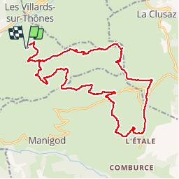
Trail Walking of 23 km to be discovered at Auvergne-Rhône-Alpes, Upper Savoy, Thônes. This trail is proposed by luccho.
Description
Tour la closette - Colomban - Croix Fry - L'Etale - Merdassier - Beauregard - les Poutassets - Le Planet - retour

Positioning
Country:
France
Region :
Auvergne-Rhône-Alpes
Department/Province :
Upper Savoy
Municipality :
Thônes
Location:
Unknown
Start:(Dec)
Start:(UTM)
295188 ; 5085468 (32T) N.
Comments