


rando Vosges du Nord chateau en chateau

micheldutilleul
User
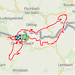

Length
57 km

Max alt
553 m

Uphill gradient
2116 m
Km-Effort
85 km

Min alt
206 m

Downhill gradient
2116 m
Boucle
Yes
Creation date :
2019-08-15 11:46:13.196
Updated on :
2019-09-16 12:31:14.946
18h28
Difficulty : Very easy

FREE GPS app for hiking
 SityTrail
IGN / Geographical institutes
SityTrail Plus
The world is yours!
About
Trail Walking of 57 km to be discovered at Grand Est, Bas-Rhin, Obersteinbach. This trail is proposed by micheldutilleul.
Description
Attention, une courte partie du tracé était à travers bois. Le chemin figurant sur la carte n'existait plus.
Positioning
Country:
France
Region :
Grand Est
Department/Province :
Bas-Rhin
Municipality :
Obersteinbach
Location:
Unknown
Start:(Dec)
Start:(UTM)
404057 ; 5432281 (32U) N.
Comments