


Nantua 17 07 2019

DFAL
User
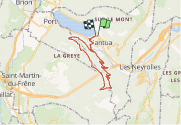

Length
14.3 km

Max alt
1123 m

Uphill gradient
658 m
Km-Effort
23 km

Min alt
474 m

Downhill gradient
668 m
Boucle
Yes
Creation date :
2019-08-17 11:22:40.0
Updated on :
2019-08-17 14:57:19.457
3h34
Difficulty : Unknown

FREE GPS app for hiking
 SityTrail
IGN / Geographical institutes
SityTrail Plus
The world is yours!
About
Trail Walking of 14.3 km to be discovered at Auvergne-Rhône-Alpes, Ain, Nantua. This trail is proposed by DFAL.
Description
14 km. 650 m D
Positioning
Country:
France
Region :
Auvergne-Rhône-Alpes
Department/Province :
Ain
Municipality :
Nantua
Location:
Unknown
Start:(Dec)
Start:(UTM)
701079 ; 5114777 (31T) N.
Comments