


Borne 2019

Spinnaker
User
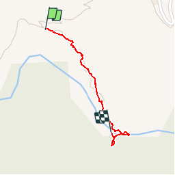

Length
524 m

Max alt
986 m

Uphill gradient
16 m
Km-Effort
734 m

Min alt
954 m

Downhill gradient
15 m
Boucle
No
Creation date :
2019-08-16 09:33:22.091
Updated on :
2019-08-17 14:59:48.519
26m
Difficulty : Very easy

FREE GPS app for hiking
 SityTrail
IGN / Geographical institutes
SityTrail Plus
The world is yours!
About
Trail Walking of 524 m to be discovered at Auvergne-Rhône-Alpes, Ardèche, Borne. This trail is proposed by Spinnaker.
Positioning
Country:
France
Region :
Auvergne-Rhône-Alpes
Department/Province :
Ardèche
Municipality :
Borne
Location:
Unknown
Start:(Dec)
Start:(UTM)
581574 ; 4941355 (31T) N.
Comments