


banneux_18_08_2019

gcolson
User
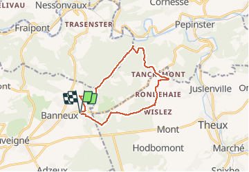

Length
11.8 km

Max alt
331 m

Uphill gradient
275 m
Km-Effort
15.4 km

Min alt
156 m

Downhill gradient
275 m
Boucle
Yes
Creation date :
2019-08-18 07:26:34.017
Updated on :
2019-08-18 10:30:30.911
3h03
Difficulty : Very easy

FREE GPS app for hiking
 SityTrail
IGN / Geographical institutes
SityTrail Plus
The world is yours!
About
Trail Nordic walking of 11.8 km to be discovered at Wallonia, Liège, Sprimont. This trail is proposed by gcolson.
Description
balade physique....
Positioning
Country:
Belgium
Region :
Wallonia
Department/Province :
Liège
Municipality :
Sprimont
Location:
Louveigné
Start:(Dec)
Start:(UTM)
694641 ; 5602176 (31U) N.
Comments
Belle et fraîche rando. À recommander !
Belle marche. En cas de pluie chaussures impermeables. Baton de marche conseille. Deniveles mais parcours ombrage.