


retour enfer

Atchoum26
User
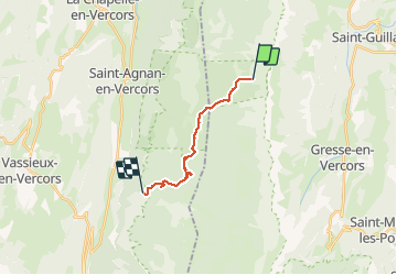

Length
11.8 km

Max alt
1760 m

Uphill gradient
172 m
Km-Effort
15.4 km

Min alt
1359 m

Downhill gradient
563 m
Boucle
No
Creation date :
2019-08-18 06:06:12.712
Updated on :
2019-08-18 11:02:52.344
3h49
Difficulty : Medium

FREE GPS app for hiking
 SityTrail
IGN / Geographical institutes
SityTrail Plus
The world is yours!
About
Trail Walking of 11.8 km to be discovered at Auvergne-Rhône-Alpes, Isère, Saint-Andéol. This trail is proposed by Atchoum26.
Positioning
Country:
France
Region :
Auvergne-Rhône-Alpes
Department/Province :
Isère
Municipality :
Saint-Andéol
Location:
Unknown
Start:(Dec)
Start:(UTM)
698051 ; 4978897 (31T) N.
Comments