


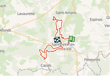
St anto 36km

Jovila
User

Length
35 km

Max alt
337 m

Uphill gradient
1249 m
Km-Effort
52 km

Min alt
118 m

Downhill gradient
1408 m
Boucle
No
Creation date :
2019-08-18 05:05:50.731
Updated on :
2019-08-19 17:17:33.425
5h20
Difficulty : Medium

FREE GPS app for hiking
 SityTrail
IGN / Geographical institutes
SityTrail Plus
The world is yours!
About
Trail Trail of 35 km to be discovered at Occitania, Tarn-et-Garonne, Saint-Antonin-Noble-Val. This trail is proposed by Jovila.
Description
Trace des trois rocs raccourcis
Positioning
Country:
France
Region :
Occitania
Department/Province :
Tarn-et-Garonne
Municipality :
Saint-Antonin-Noble-Val
Location:
Unknown
Start:(Dec)
Start:(UTM)
401260 ; 4889714 (31T) N.
Comments