


pas de l aiguille vercors

grandfifi
User
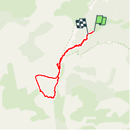

Length
6.7 km

Max alt
1692 m

Uphill gradient
542 m
Km-Effort
13.8 km

Min alt
1189 m

Downhill gradient
500 m
Boucle
Yes
Creation date :
2019-08-18 08:13:31.06
Updated on :
2019-08-19 16:43:08.378
3h49
Difficulty : Medium

FREE GPS app for hiking
 SityTrail
IGN / Geographical institutes
SityTrail Plus
The world is yours!
About
Trail Walking of 6.7 km to be discovered at Auvergne-Rhône-Alpes, Isère, Chichilianne. This trail is proposed by grandfifi.
Positioning
Country:
France
Region :
Auvergne-Rhône-Alpes
Department/Province :
Isère
Municipality :
Chichilianne
Location:
Unknown
Start:(Dec)
Start:(UTM)
699549 ; 4965685 (31T) N.
Comments