


retour Sainte odilr

raydiez
User
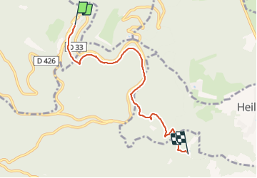

Length
5.5 km

Max alt
769 m

Uphill gradient
20 m
Km-Effort
7 km

Min alt
404 m

Downhill gradient
380 m
Boucle
No
Creation date :
2019-08-18 13:22:40.544
Updated on :
2019-08-18 14:57:47.116
1h23
Difficulty : Very easy

FREE GPS app for hiking
 SityTrail
IGN / Geographical institutes
SityTrail Plus
The world is yours!
About
Trail Walking of 5.5 km to be discovered at Grand Est, Bas-Rhin, Ottrott. This trail is proposed by raydiez.
Description
Pas de description
Positioning
Country:
France
Region :
Grand Est
Department/Province :
Bas-Rhin
Municipality :
Ottrott
Location:
Unknown
Start:(Dec)
Start:(UTM)
381967 ; 5366126 (32U) N.
Comments