


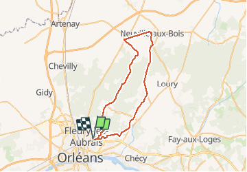
Boucle Orléans Neuville

norihtom
User

Length
48 km

Max alt
151 m

Uphill gradient
316 m
Km-Effort
52 km

Min alt
103 m

Downhill gradient
316 m
Boucle
Yes
Creation date :
2014-12-10 00:00:00.0
Updated on :
2014-12-10 00:00:00.0
2h46
Difficulty : Very easy

FREE GPS app for hiking
 SityTrail
IGN / Geographical institutes
SityTrail Plus
The world is yours!
About
Trail Other activity of 48 km to be discovered at Centre-Loire Valley, Loiret, Orléans. This trail is proposed by norihtom.
Positioning
Country:
France
Region :
Centre-Loire Valley
Department/Province :
Loiret
Municipality :
Orléans
Location:
Unknown
Start:(Dec)
Start:(UTM)
420582 ; 5308841 (31T) N.
Comments