


manerbe

jchezlemas
User
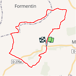

Length
8.9 km

Max alt
149 m

Uphill gradient
180 m
Km-Effort
11.3 km

Min alt
67 m

Downhill gradient
179 m
Boucle
Yes
Creation date :
2019-08-19 07:07:46.876
Updated on :
2019-08-19 16:05:37.517
2h40
Difficulty : Very easy

FREE GPS app for hiking
 SityTrail
IGN / Geographical institutes
SityTrail Plus
The world is yours!
About
Trail Walking of 8.9 km to be discovered at Normandy, Calvados, Manerbe. This trail is proposed by jchezlemas.
Positioning
Country:
France
Region :
Normandy
Department/Province :
Calvados
Municipality :
Manerbe
Location:
Unknown
Start:(Dec)
Start:(UTM)
292654 ; 5451723 (31U) N.
Comments