


les cabanes Luzenac-MNT

c.chehere
User
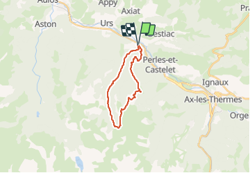

Length
23 km

Max alt
1819 m

Uphill gradient
1286 m
Km-Effort
40 km

Min alt
619 m

Downhill gradient
1288 m
Boucle
Yes
Creation date :
2019-08-20 10:45:32.544
Updated on :
2019-09-01 08:30:28.45
8h07
Difficulty : Very difficult

FREE GPS app for hiking
 SityTrail
IGN / Geographical institutes
SityTrail Plus
The world is yours!
About
Trail Walking of 23 km to be discovered at Occitania, Ariège, Luzenac. This trail is proposed by c.chehere.
Positioning
Country:
France
Region :
Occitania
Department/Province :
Ariège
Municipality :
Luzenac
Location:
Unknown
Start:(Dec)
Start:(UTM)
398859 ; 4734784 (31T) N.
Comments