


col du sabion

baygonvert
User
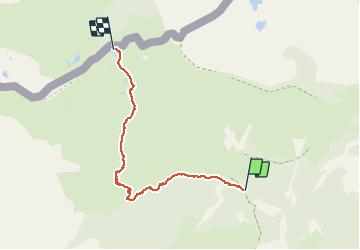

Length
5.2 km

Max alt
2265 m

Uphill gradient
571 m
Km-Effort
11 km

Min alt
1718 m

Downhill gradient
48 m
Boucle
No
Creation date :
2019-08-18 08:02:11.81
Updated on :
2019-08-20 13:13:23.642
3h02
Difficulty : Very easy

FREE GPS app for hiking
 SityTrail
IGN / Geographical institutes
SityTrail Plus
The world is yours!
About
Trail Walking of 5.2 km to be discovered at Provence-Alpes-Côte d'Azur, Maritime Alps, Tende. This trail is proposed by baygonvert.
Positioning
Country:
France
Region :
Provence-Alpes-Côte d'Azur
Department/Province :
Maritime Alps
Municipality :
Tende
Location:
Unknown
Start:(Dec)
Start:(UTM)
379553 ; 4885726 (32T) N.
Comments