


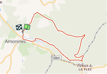
Amonines

Peter.vdbergh
User GUIDE

Length
9.3 km

Max alt
467 m

Uphill gradient
195 m
Km-Effort
11.9 km

Min alt
290 m

Downhill gradient
196 m
Boucle
Yes
Creation date :
2019-08-20 15:30:45.249
Updated on :
2021-08-22 11:29:39.347
3h05
Difficulty : Medium

FREE GPS app for hiking
 SityTrail
IGN / Geographical institutes
SityTrail Plus
The world is yours!
About
Trail Walking of 9.3 km to be discovered at Wallonia, Luxembourg, Érezée. This trail is proposed by Peter.vdbergh.
Description
WaAndNatuur 17:Amonines (PVDB)
Photos


Positioning
Country:
Belgium
Region :
Wallonia
Department/Province :
Luxembourg
Municipality :
Érezée
Location:
Unknown
Start:(Dec)
Start:(UTM)
682551 ; 5571605 (31U) N.
Comments