


einville par le canal

babouille
User
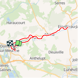

Length
25 km

Max alt
230 m

Uphill gradient
144 m
Km-Effort
27 km

Min alt
203 m

Downhill gradient
145 m
Boucle
Yes
Creation date :
2019-08-20 14:58:11.331
Updated on :
2019-08-20 16:51:00.778
1h51
Difficulty : Very easy

FREE GPS app for hiking
 SityTrail
IGN / Geographical institutes
SityTrail Plus
The world is yours!
About
Trail Mountain bike of 25 km to be discovered at Grand Est, Meurthe-et-Moselle, Dombasle-sur-Meurthe. This trail is proposed by babouille.
Description
vélo
Positioning
Country:
France
Region :
Grand Est
Department/Province :
Meurthe-et-Moselle
Municipality :
Dombasle-sur-Meurthe
Location:
Unknown
Start:(Dec)
Start:(UTM)
305580 ; 5388662 (32U) N.
Comments