


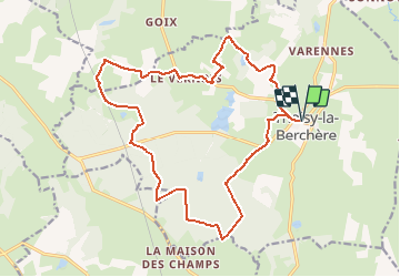
Thoisy Ouest

jeanboulay
User

Length
19.5 km

Max alt
504 m

Uphill gradient
235 m
Km-Effort
23 km

Min alt
409 m

Downhill gradient
235 m
Boucle
Yes
Creation date :
2019-08-20 21:10:36.948
Updated on :
2019-08-20 21:11:29.538
1h31
Difficulty : Medium

FREE GPS app for hiking
 SityTrail
IGN / Geographical institutes
SityTrail Plus
The world is yours!
About
Trail Mountain bike of 19.5 km to be discovered at Bourgogne-Franche-Comté, Côte-d'Or, Thoisy-la-Berchère. This trail is proposed by jeanboulay.
Positioning
Country:
France
Region :
Bourgogne-Franche-Comté
Department/Province :
Côte-d'Or
Municipality :
Thoisy-la-Berchère
Location:
Unknown
Start:(Dec)
Start:(UTM)
601763 ; 5235151 (31T) N.
Comments
nous avons combiné les différents circuits vtt proposé par jeanboulay autour de Mont saint jean et nous avons ainsi pu faire une belle découverte de ce coin que nous ne connaissions pas du tout. A part un ou deux endroits où le tracé GPS nous amenait dans des champs, le circuit est très roulant et permet de passer dans les villages, les forêts...