


montclus 20 août 2019

elorthiois
User
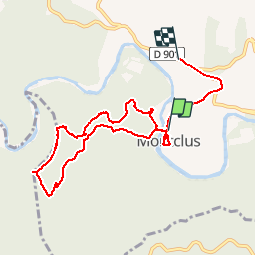

Length
8.9 km

Max alt
313 m

Uphill gradient
314 m
Km-Effort
13 km

Min alt
85 m

Downhill gradient
278 m
Boucle
No
Creation date :
2019-08-21 05:51:32.453
Updated on :
2019-08-21 09:44:02.843
3h51
Difficulty : Easy

FREE GPS app for hiking
 SityTrail
IGN / Geographical institutes
SityTrail Plus
The world is yours!
About
Trail Walking of 8.9 km to be discovered at Occitania, Gard, Montclus. This trail is proposed by elorthiois.
Positioning
Country:
France
Region :
Occitania
Department/Province :
Gard
Municipality :
Montclus
Location:
Unknown
Start:(Dec)
Start:(UTM)
613371 ; 4902002 (31T) N.
Comments