


Vens rabuons

PEBREJOSIANE
User
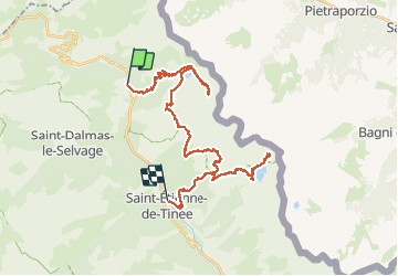

Length
40 km

Max alt
2662 m

Uphill gradient
2366 m
Km-Effort
73 km

Min alt
1142 m

Downhill gradient
2766 m
Boucle
No
Creation date :
2019-08-19 07:32:35.44
Updated on :
2019-08-21 12:43:33.316
20h24
Difficulty : Very easy

FREE GPS app for hiking
 SityTrail
IGN / Geographical institutes
SityTrail Plus
The world is yours!
About
Trail Walking of 40 km to be discovered at Provence-Alpes-Côte d'Azur, Maritime Alps, Saint-Dalmas-le-Selvage. This trail is proposed by PEBREJOSIANE.
Positioning
Country:
France
Region :
Provence-Alpes-Côte d'Azur
Department/Province :
Maritime Alps
Municipality :
Saint-Dalmas-le-Selvage
Location:
Unknown
Start:(Dec)
Start:(UTM)
332559 ; 4908502 (32T) N.
Comments