


de nant à cantobre

labarone
User
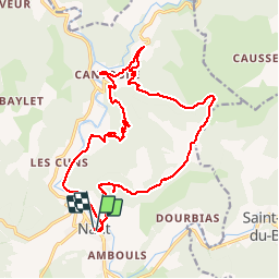

Length
21 km

Max alt
864 m

Uphill gradient
810 m
Km-Effort
32 km

Min alt
469 m

Downhill gradient
806 m
Boucle
Yes
Creation date :
2019-08-21 06:26:27.801
Updated on :
2019-08-21 14:01:15.124
7h31
Difficulty : Medium

FREE GPS app for hiking
 SityTrail
IGN / Geographical institutes
SityTrail Plus
The world is yours!
About
Trail Walking of 21 km to be discovered at Occitania, Aveyron, Nant. This trail is proposed by labarone.
Description
En passant par le roc nantais et le mas balmarelesse
2 bonnes montees..
Village de cantobre magnifique à voir absolument... Voir photos... Un resto qui a l air très bien
A FAIRE !!!!
Photos


Positioning
Country:
France
Region :
Occitania
Department/Province :
Aveyron
Municipality :
Nant
Location:
Unknown
Start:(Dec)
Start:(UTM)
524227 ; 4874386 (31T) N.
Comments