


Peyrolles

ja.13061965
User
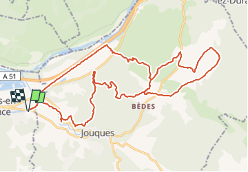

Length
28 km

Max alt
438 m

Uphill gradient
458 m
Km-Effort
34 km

Min alt
218 m

Downhill gradient
458 m
Boucle
Yes
Creation date :
2019-06-20 09:33:16.25
Updated on :
2022-01-28 14:00:24.151
3h04
Difficulty : Easy

FREE GPS app for hiking
 SityTrail
IGN / Geographical institutes
SityTrail Plus
The world is yours!
About
Trail Mountain bike of 28 km to be discovered at Provence-Alpes-Côte d'Azur, Bouches-du-Rhône, Peyrolles-en-Provence. This trail is proposed by ja.13061965.
Positioning
Country:
France
Region :
Provence-Alpes-Côte d'Azur
Department/Province :
Bouches-du-Rhône
Municipality :
Peyrolles-en-Provence
Location:
Unknown
Start:(Dec)
Start:(UTM)
709884 ; 4835687 (31T) N.
Comments